


Free delivery to all European Community Countries
Product description
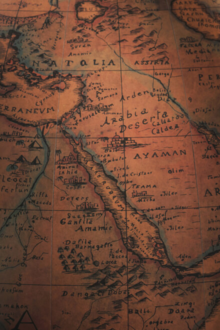
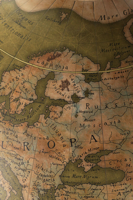
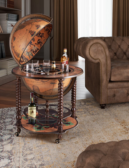
WORLD MAP OR GENERAL DESCRIPTION OF THE GLOBE WITH THE JOURNEYS AND NEW DISCOVERIES OF CAPTAIN JAMES COOK, G. Cassini – 1788
The graphic representation of terrestrial shape goes back many years in spite of man’s scarce geographical knowledge, limited knowledge of mathematical and geometrical equations and the lack of accurate means for measuring. All these factors made it extremely difficult to even attempt to create cartographic representations. The first sketches were created because of the physical need to know and precede the use of writing; they are schematic representations of clear planimetric details, suitable for finding an already known itinerary. Similar devices, proportioned according to the limited needs and restraints in which primitive people first lived, slowly gave way to more and more expressive descriptions and as the horizons widened together with man’s knowledge and needs, the development of a more stable means of measurement and representation became indispensable. From small, bordered areas to the representation of vast territories to finally a global depiction of the entire terrestrial surface. The irrational and primitive mapmaking in the Medieval period was overcome by the spread of the Geography by Ptolemy, aided by the invention of the printing press, (1446).
Although this work analyzes and describes those parts of the Earth then known, it also defines its general foundation and the system of enlarging the Earth’s representation in a logical way, thanks to the newest geographical discoveries. At the end of the 15th century, the concept of the world being round was well accepted by the most important figures of the time as well as having been proved by the great sea voyages that took place after the discovery of the Americas. Therefore, more precise geographic corollaries and research on more efficient instrumental means were developed. But it was only in the 18th century that the shape of the Earth became truly defined. After having perfected measuring instruments and obtained an international organization of specialized studies and geodetic measurements, the creation of large national maps and cartographic representations were produced based on the world known at that time. The map of the world represented here is the work of the geographer G. Cassini and it is without doubt an important piece for its varied and updated information that were the result of the voyages and discoveries carried out by the famous English explorer, James Cook, (1728-1779).
This important figure made three long journeys. In the first one, (1768-1771), he crossed the Pacific Ocean discovering the Society Islands, New Zealand and the east coast of Australia, ascertaining the separation between them, contrary to prior beliefs. The second journey took him to the South Pole in the search of the southern most continent. Unfortunately, he was forced to stop because of the ice and snowstorms at 71st 10’ latitude. He then traveled northwards to the Easter Islands and the Marquesas Islands, exploring the Society Islands, Loyalty Islands, the New Hebrides and New Caledonia. He returned to New Zealand and sailed around the 54th and 55th parallels heading first towards Cape Horn and then towards Cape of Good Hope without finding any great amount of land along the line bordered by ice. In his third voyage he looked for the passage leading to the northern part of America. He went to the Bering Straits in the Pacific and along the way discovered the Sandwich Islands. He followed the American coast from the45th parallel to Alaska. He arrived beyond the strait up to the 70th 44’ latitude where the masses of ice stopped him from proceeding. He returned to the Sandwich Islands in order to spend the winter there but was murdered by one of the natives.
In the footsteps of James Cook with an eighteenth-century planisphere
The technique used to produce this map is the same one employed by ancient mapmakers: A manual press, finely engraved plates and 100% cotton paper. The actual mounting on cotton canvas reflects the manufacturing procedure frequently used in the past because with this method cartographic representations could be better preserved and it was also easier to carry them. Of course only the aging process, achieved with natural substances, was not used by the ancient mapmakers for obvious reasons. The watercoloring effect gives the subject a polychromatic image of indubitable visual effect. It is thanks to the use of these materials and techniques that this work is recreated enabling it to renew the beauty and historical-cultural value of the original.
*** Our canvases are printed with a hand press and are produced on request only. It takes about 10 days for the Black & White version and about 20 days for the Hand-painted.
Attention: the canvases are delivered without frame.
Technical features
Trustpilot store reviews
Customers who bought this product also bought:


